|
|||||
| |
|||||
|
|||||
| 6a | |||||
|
Home | Amanos
Mtn. | Project Area
| List of species 1
/ 2 |
EEA
| CORINE
|
|||||
|
||||||||||||||||||||||||
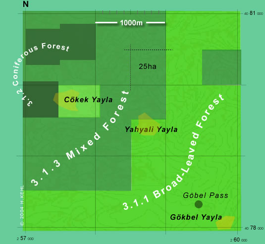
| EXAMPLE for CORINE Land Cover classification | |||||||||||
| Preliminary mapping of only 9 km² according to CORINE LCC on the basis of Digital Classification of Vegetation using Landsat TM-data of September 1989 and Thematical Ecological Maps (TEMap 8), prepared for the research project LöKAT (1997 and 1998): | |||||||||||
| Example from the Amanos Mtn., above Dörtyol (550 - 1000m) - between Çökek Yayla and Gökbel Pass. | |||||||||||
|
Please note: This example of CORINE LCC should serve only as an introduction, and will give only an idea about the different biophysical units in the area of research and excursion. The inventory should be based primarely on satellite scenes of Landsat TM data of different vegetation periods with additional information on topography, and e.g. orthogonal photos. |
|||||||||||
| Adopted from Kehl,H. (1998) TEMap8 'Digital Classification of Vegetation using Landsat TM-data of Sept. 1987' | |||||||||||
 |
|||||||||||
| Scale, background map and labelling only for orientation and comparison! | |||||||||||
|
|||||||||||
|
NOTE:
Applied mapping wouldn't use the presented scale for CLC! |
|||||||||||
| EEA
data service Corine
land cover 2000 by country online
|
|||||||||||
| More information at the European Topic Centre on Terrestrial Environment online | |||||||||||
| EXAMPLE (same area, and for comparison) for EUNIS Habitat classification | |||||||||||
|
|
|||||||||||
Copyright
© Dr. Harald Kehl
Alumnus of TU-Berlin - Institute of Ecology
Last updated
on
2019-10-09