| Back to 2nd page (with synopsis) |
p.
04 of 11
|
|||
|
|
||||
| Back to last page |
Next
page
|
|
||
The Pinus brutia forest is relatively well-preserved because the state forest, with rather rigid controls against wood extraction, begins right outside the village (oral comm. Düzlercami). Undergrowth is only sporadic due to extraction by the villagers, and intense grazing, at least near the village. At some distance from the village the state forest has dense Macchie undergrowth.
A similar situation is encountered on either side of the road to Antalya, leaving the village to the east. However, there is thick undergrowth under a continuous Pinus brutia forest directly from the edge of the village. The villagers say that this area was privately owned until a few years ago, and grazing and wood-extraction were strictly controlled.
The periphery of the village to the north and south has an extensive pasture-type vegetation, with a mosaic of small shrub complexes intruding more frequently with increasing distance from the village. These complexes merge to form larger and larger units, with some individuals (Quercus coccifera, Phillyrea latifolia and Pistacia terebinthus) reaching heights of 2 to 4m. At some distance from the village the first isolated Pinus brutia occur, and at a greater distance these form smaller continuous stands.
The marked decline in the numbers of species between positions 20 and 25 coincides with the high dominance of only a few therophytes and a high abundance of species indicating degradation in the pronounced extensive pasture ranges, already a euhemerobic zone of the settlement periphery (cf. Fig. 5). The distribution of the determined CaS groups shows marked differences primarily between the CaS of the Macchie and 'Phrygana' on the one hand, and on the other hand of the extensive pastures and the Macchie clearings, which are rich in therophytes. In contrast to the more-or-less constant numbers per relevee of phanerophytes and chamaephytes of the Macchie and the chamaephytes of the Phrygana, the proportions of therophytes and hemi-cryptophytes of the extensive pastures and Macchie clearings increase the nearer one comes to the village. Although the last-mentioned group is not completely absent from the village centre, it has only a very low cover.
The extensive pasture zone to the south of the village represents the real distribution boundary of the trampling and segetal vegetation, and with some reservations of the ruderal vegetation. It should be noted that some CaS of the Hordeum leporinum - Chenopodium murale association (e.g., Hirschfeldia incana, Sisymbrium officinale and Crepis foetida) stretch far into the boundary zone of the Macchie and Phrygana associations.
There is a marked difference in the proportional dominance of the characteristic groups. In particular the phanerophytes (cf. Table 1) of the Macchie, Quercus coccifera, Phillyrea latifolia and Pistacia terebinthus, as well as Pinus brutia, display high cover values from the start to the middle section of the transect, which then decline almost linearly to the edge of the village. Although the Quercus coccifera is well represented in all relevees, it becomes less and less frequent in the upper shrub stratum II (1-3 m), and grows in the extensive pastures in cushion shaped formations where it scarcely exceeds 1 m.
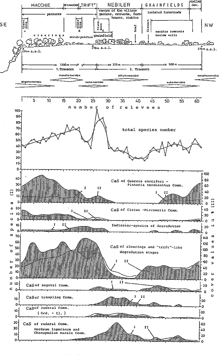
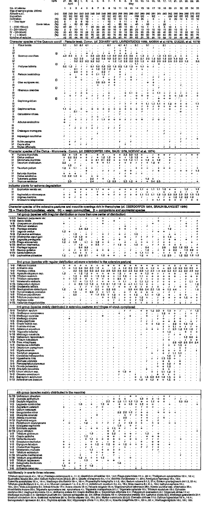
The marked drop of species diversity in the extensive pastures reflects the high dominance of Evax eriosphaera (cf. Fig. 9) and Asteriscus aquaticus, which occur only here, as well as Plantago cretica and Pl. lagopus, well represented in all relevees which form a thick carpet in some places. Adjacent clearings or free areas are frequently dominated by a single species. Although the character species of the Phrygana generally show an even distribution, declining only on the extensive pasture ranges, the cover values do increase somewhat near the edge of the escarpment, namely by Cistus creticus, C. salviifolius and Thymus revolutus.
Of the indicator species for degradation or severe overgrazing (cf. Walter 1968: 75, Knapp 1965: 138, Polunin 1977: 173), above all the two geophytes Asphodelus microcarpus and Urginea marititma should be mentioned, since they have their greatest distribution in the highly degraded Macchie of the 'mixed zone' and in the extensive pastures. Euphorbia sibthorpii has an increased dominance on the extensive pastures and the adjacent zones, but is also present sporadically over the entire area of investigation.
On the fields themselves there are isolated bush-complexes of Quercus coccifera and Phillyrea latifolia, as well as some proud Pinus brutia on the eastern edge of the village. To the north the Pistacia terebinthus stand is harvested to provide fodder.
When considering the two transects through the settlement it should be borne in mind that the 2nd transect cuts across the fields on the southern edge of the village, so that small bush complexes growing against the stone walls are represented to a greater extent in the vegetation relevees (cf. Fig. 5, mixed zone C). Both in the eastern section of the 3rd transect (cf. Table 3 - not included in this publication!) and in the northern area of the village, there has been sporadic settlement along the existing routes. In order to determine the floristic composition and distribution in these areas the transects were laid through the above mentioned settlement areas.