UNDER THE INFLUENCE OF A SMALL SETTLEMENT NEAR ANTALYA
(SW-TURKEY)
Rothenburgstr. 12, D-12165 Berlin, Germany
|
p.
02 of 11
|
SUKOPP, H., M. NUMATA & A. HUBER (1995) (eds.) Urban Ecology as the Basis of Urban Planning.-
© SPB Academic Publishing bv, Amsterdam, The Netherlands: pp 85-150.
The Mediterranean countries, which are among the oldest cultural areas on earth, possess a plant cover rich in species and formations, which are generally understood to result from degradation and human influence reaching back far into history.
However, according to the recent publication of Hempel (1981, 1983) human populations played a much less important role in the origins of present-day vegetation and the appearance of erosion. Human reduction of forest areas is assumed, but the crucial soil dis-placement is shown to have occurred in the subboreal to early Atlantic period.
It is generally agreed that relative to the vegetation of Central Europe (see Sukopp 1979), the Mediterranean vegetation is more original in its composition (Schwarz 1936, Braun-Blanquet 1936, Walter 1968, Schmidt 1969, Zohary 1973). Furthermore, many of its elements are felt to have high ecological resistance and ability to regenerate.
Remnants of Mediterranean shrub formations can often be identified in the immediate settlement area. Strongly devastated Macchie formations with mantle communities and forb fringes, which have been under high grazing pressure, are able to spread and regenerate rapidly if protected (Greuter 1975a, Amir & Sarig 1976, Godron et al. 1981). This raises the question of a systematic relationship between human influence and the real dynamics of semi-natural and anthropogenically influenced flora and vegetation.
This paper attempts to cast light on these questions, taking as an example the influence on the vegetation development of a small Turkish settlement on the south-west Anatolian coast near Antalya.
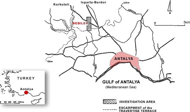
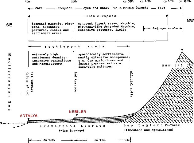
Forming a barrier to the Anatolian Highlands, the south-western Taurus Chain thus en-closes one of the few large bays on the Turkish south coast. Characterised by marked karst features, such as karren fields, karst plateaus, polje and swallow-holes (doline), the Taurus chain consists mainly of Mesozoic and Tertiary limestone, shale and ophiolite suites (Planhol 1956, Wippern 1962). Comparative geomorphological investigation of the physiographically uniform travertine terracing in front of the Taurus mountains (see Pfannenstiel 1952, 1953, Özbey 1960-61, Biju-Duval & Montadert 1977, Planhol 1956, Barkot & Erinc 1951) have established marked similarities to terracing and to wave-cut grooves and notches elsewhere on the Mediterranean coast. It is generally assumed that this is attributable to eustatic changes in sea level (see the comparisons in Jahn 1970: Fig. 8).
The Antalya Plain (cf. Fig. 2), covering an area of about 130 km2 is one of the most expansive travertine terraces of the Mediterranean. Morphogenetically it consists of calcareous sinter deposits of acidic spring water from the Taurus mountains, forming layers of crystalline CaCO3. High evaporation levels, and the fact that karst water is usually richer in CO2 in Mediterranean areas (Sweeting 1972: 108) allow widespread deposition of travertine and tuff.
Plant fragments are often included in travertine, so that its structure is generally heterogeneous (see Steiner 1979: 30, Muranski 1938: 204, on the increased calcareous deposition due to plant fragments). Deposition processes can still frequently be observed at waterfalls on the steep coast near Antalya.
The Mediterranean south-west coast of Turkey, in the thermo-Mediterranean climate zone (UNESCO-FAO 1963: 33) is characterised by heavy winter precipitation and a very hot dry summer, due according to Zohari (1973: 31) to the southern exposure of the Taurus chain.
In the summer the coastal strip of Turkey lies in the range of the arid sub-tropics (cf. Walter 1968: 50, Christiansen-Weniger 1962: 229) and in the dry period experiences dry air masses and the influence of high-pressure zones. In the winter the cyclonic rains of the temperate zones dominate the whole of the Mediterranean coastal region of Turkey and lead to extremely high levels of precipitation.
The southern exposure of the slopes of the Taurus plays an important role in the distribution of rainfall. The mountains act as a barrier, protecting the coastal region from the in-fluences of the highlands, while leading to increased precipitation in the hinterland of Antalya to the west, north and east, as humid air masses are held back in the hinterland of Antalya. Most of the humidity is deposited in the form of orographic rain (Meyer 1967, 1968: 39). The observation reported by Zech & Cepel (1972: 13) that the annual precipita-tion in the hinterland of Antalya has risen by about 50% (from an average of 1050mm to approx. 1500mm) (cf. Fig. 3) is of considerable significance for the area under investigation. Personal records (1979-1980) showed that the period free of rain was about 2 to 3 weeks shorter than in the vicinity of the measuring station of Antalya.
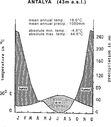
- Although the continuous records over the last 50 years from the Antalya climate station cannot be transferred unreservedly to the area under investigation, which lies 15 km north-west and 270 m above sea level, the recorded data represent the climatic conditions over the coast region in general.
However, the mean temperatures only give a vague idea of the actual conditions. The highest measured temperature was 49.2°C in August 1979, apart from which Antalya experienced 86.8 tropical days (temperature during the day above 30°C), and 160.9 summer days (temperature during the day above 26°C) (Met. Bült. 1969). Frosts only occur occa-sionally in winter. However, due to the pressure gradient between a high-pressure region above the 1000m higher Inner Anatolia and the Cyprus depression, a north-south flow over the borderhills (Taurus - Toros) can give rise to cold descending wind at the coast, with marked cold snaps and sudden drops of temperature below the freezing point.
The arid period lasts from April to October. It is marked by a drop in the monthly precipitation below the aridity index of 30mm, Jahn (1970: 20) calculated after De Martonne (1927) and Lauer (1952: 15-98). The water budget, calculated using Thornthwaite's method (1948), shows a water deficit between June and October of 582mm (lufro 1975: 14). The mean annual relative air humidity of the coastal region is 64% and below 60% in the months June to September. A possible explanation could be the prevailing NW to N winds, which bring with them comparatively dry air from the highlands. Of particular importance for the Mediterranean vegetation is the high intensity of the insolation. From mid-March to approximately mid-October between 8 and 13 hours mean daily hours of sunshine were measured, and even in the winter the sun shines for an average of 5 hours per day (Met. Bült. Ankara 1962, 1967, Met. Stat. Antalya 1966).
Last updated on 23.06.2021 5:29 PM