
- Formations:
Hilly (colline) to middle montane belt: mesozoic ophiolite suites (black and green serpentinites); mainly middle montane belt: mesozoic - tertiary limestone series; (middle) upper montane - subalpine: paleozoic sandstone series.
- Proved
 Soil Units
(PDF-File: 40K) according
to FAO-UNESCO
(1988):
Soil Units
(PDF-File: 40K) according
to FAO-UNESCO
(1988):
Trends and intensity of soil-forming processes are - especially under current utilization intensities - basically subject to relief conditions. In the sense of soil genetical defined chronosequences, highly developed soils were found (independent of relief position!) on all rock formations.
- Dependent on variant
rock structures (of the three formations), the evolutionary progress
and depth of soils is different. Particularly mesozoic deep-seated
rocks and palaeozoic sandstones are deeply weathered. In the area under
investigation, generally the depth of soils reflects the economical
utilization of the landscape.
- Clay migration
(illimerisation) has been detected in all highly developed soils
- Vegetation
poverty as a result of high concentrations of plant available heavy
metal compounds, often described as typical for soils, derived from
serpentinite, has not been detected in the research area.
- Soil Moisture:
Soils derived from limestone are characterized by the highest field capacity (FC). It is explained by the lowest content of skeleton, the highest percentage of humus, clay and silt. In contradiction, the lowest field capacity (FC) has been found in soils derived from serpentinite and sandstones. Soils derived from serpentinite are deeply weathered, very rich in skeleton with high contents of sand, low percentages of humus in the topsoil (A-horizon), and the lowest available FC.
Soils with the most favorable requirements for evaporation avoiding water absorption (e.g. fast and advantageous water intake without evaporation loss) during summer with low precipitation and high evaporation rates, are deeply weathered soils with high water permeability in the surface soil (e.g. low content of humus and clay), located at northerly exposed and shady slopes. These pronounced preconditions were achieved faster especially by soils derived from sandstone under less favorable precipitation conditions, than by soils derived from limestone.
The exceptional soil moisture conditions from July (August) until middle of September have been detected to be of exclusive relevance for the distribution of the extrazonal vegetation. The desiccation period in July decreases with increasing altitude. Generally, shallow and eroded soils dry up quickest. Under the above mentioned conditions shortages in water balance have been observed especially in the hilly landscapes (colline belt) and the upper montane to subalpine belt.
- Nutrient
Supply:
Under aspects of forestry in soils of all rock formations, the long and short termed nutrient supply can be described as adequate.
Very different pH Values in soil solutions depend on relief positions, where soils have been developed. Generally, soils of high slopes derived from sandstone are characterized by very low pH Values. However, pH Values between 5.5 - 6 in the Ah Horizon can be observed also in very well developed soils (Luvisols and Phaeozems with clay migration) derived from limestone (mostly dolomite) of small sized areas on northerly exposed slopes of the middle montane belt with high precipitation rates.
The cation exchange capacity (CEC) depend to the pH Values and is therefore in soils derived from sandstone mostly 'low' to 'middle'. In contradiction, the CEC is high in soils developed on different limestones with neutral or low alkaline soil solutions.
- A significant
relationship between soil physical and chemical site conditions and
vegetation distribution has been found ONLY in the area of
the sandstone formation.
- For the establishment and distribution of plants of Euxinian origin generally, the soil water availibility during the hot summer season (with low precipitation rates and extremely high evaporation) has to be interpreted as the most important ecological factor. Thereby highly developed soils in the sense of soil genetical defined chronosequences are of greater importance than their parent rocks. Nevertheless, favorable soil conditions have obviously been attained faster by soils derived from sandstone than from serpentinite and limestone.
For documentation of Soil Units (cf.
) according to FAO-UNESCO a 'Thematical Ecological Map' was developed.
- Precipitation:
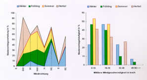 Precipitation
conditions at the westerly exposed slopes of the Amanus Mtn. are generally
determined by the different seasonal macro-climatic weather.
Climatologically the mountain ranges are effected mainly by southerly
roaming low pressure areas during winter season and etesian winds
(a drift of air masses between a low pressure area located between
the Pontus and Toros ranges bordering the anatolian highland and a
high pressure area above the eastern Mediterranean Sea) during summer
season. The originally dry etesian winds - called Meltemi in Turkey
- of the northeast Mediterranean enriches its water vapor on its way
from west to east along the coast and obtains a monsoonal character.
The north-south stretching Amanus Mtn. range is damming up these damp
humid air masses with the result of frequent cloudbank formations
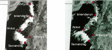
(cf.
satellite images)
(PDF-File: 306K)
during summer time with frequent precipitation events of very different
intensities.
Precipitation
conditions at the westerly exposed slopes of the Amanus Mtn. are generally
determined by the different seasonal macro-climatic weather.
Climatologically the mountain ranges are effected mainly by southerly
roaming low pressure areas during winter season and etesian winds
(a drift of air masses between a low pressure area located between
the Pontus and Toros ranges bordering the anatolian highland and a
high pressure area above the eastern Mediterranean Sea) during summer
season. The originally dry etesian winds - called Meltemi in Turkey
- of the northeast Mediterranean enriches its water vapor on its way
from west to east along the coast and obtains a monsoonal character.
The north-south stretching Amanus Mtn. range is damming up these damp
humid air masses with the result of frequent cloudbank formations
(cf.
satellite images)
(PDF-File: 306K)
during summer time with frequent precipitation events of very different
intensities. The amount and pattern of precipitation is varies extremely from year to year, but especially during summer seasons. Under the influence of the above mentioned seasonal different precipitation conditions, the easterly (!) exposed slopes are precedented during winter season. In contradiction, under the influence of the vapor rich etesian winds during late spring, summer and early autumn, nearly exclusively the westerly exposed slopes enjoy high precipitation rates.
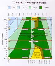
The coastal plain of the Dörtyol area show already a more or less humid climate. And the transition range from the hilly landscape to the upper montane belt belongs completely to humid to the per-humid type of bioclimate. Moreover, the complete montane and subalpine belt is to be added to the per-humid type of bioclimate according to EMBERGER (1955). Therefore the investigated western slopes of the Amanus Mtn. above Dörtyol show typical humid altitudinal belts.
Summarizing it can be concluded that the actual Extrazonal Vegetation of the investigated slopes with extremely strong affinities to Balkan and Pontos vegetation types owes its existence nearly exclusively to precipitation conditions caused by special effects of typical mediterranean (!) etesian winds of the summer season.
The average precipitation amount of the coastal plain around Dörtyol is quoted with 1.022 mm/y. During the period of data collection, the following yearly means were measured at different altitudes: 1.300 mm (500 m a.s.l.), 2.300 mm (950 m a.s.l.), 1.800 mm (1.600 m a.s.l.) and 1.300 mm (2.100 m a.s.l.)
- Global Radiation:
An extreme decrease of global radiation during summer season caused by cloudbank formations (cf.
Decrease
of Global Radiation
PDF-File: 26K) - especially in the middle montane belt - was observed.
In comparison with (theorectically) cloudless sky, the average reduction
of global radiation under conditions of cloudbank formations is more
than 40%. Under consideration of inclination, exposition and mean values of cloud cover, highly significant correlations have been found between the distribution of vegetation units resp. species populations and the altitudinal gradient of global radiation.
-
Temperature:
(PDF-File: 128K)
The yearly mean altitudinal temperature decrease is 0.61 °C/100 m (200 cm above ground). This value is changing seasonally and not linear on the altitudinal gradient. During summer season, one can observe a very steep gradient between the coastal plain and middle montane belt, which can be interpreted as a result of reduced global radiation values effected by cloudbank formations.
The gradient of temperature between the soil surface and 200 cm above ground is getting steeper with increasing altitude as a result of an increasing surface heating.
- Spectrum of Geoelements:
610
species
(PDF-File: 238K)
were proved for the research area (incl. 13 species named by AKMAN
[1973] for the slopes above Dörtyol).
NEW: The Web Project
"Plant Species
/ Families of the Amanos Mtn., NW-Slopes above Dörtyol (SE-Turkey,
Hatay Province)
coll. & det. in the Framework of the Research Project LöKAT" has been launched in 2011 March, incl. Herbarium Specimen (digitized) and a great number of Plant Species Photographs.
Geobotanically, the middle montane belt nowadays has proportionally nearly 44% species of Euro-Siberian origin. In the upper montane belt, this portion rises to more than 63%. The altitudinal distribution of geoelements is determined by the above mentioned unique climate conditions. Cloud bank formations as regulators of radiation balance during summertime have to be interpreted as the climate variable with the highest value of explanation. In addition, the relief exposition of species sites is of great importance (cf.
exposition of
sample sites
PDF-File: 488K) However, present abundance and dominance of species and their populations are determined essentially by anthropo-zoogenous impacts of different intensities (called 'hemerobic degrees' according to JALAS (1953) and SUKOPP (1968), e.g. woodland pasture, wood consumption for different purposes and the above mentioned infrastructural development resulting in soil erosion). In has been observed that habitat changes caused by extensive and intensive economical influence very often resulted in soil erosion with inauspicious disadvantages of the soil water balance. Especially Euro-Siberian geoelements were pushed back and their reestablishment disabled. At least euryvalent low-grade east-mediterranean species with wide amplitudes of growing conditions prevail.
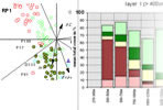
The
Mean Total Cover Values of Geoelements for Different Layers and
Altitudes
(PDF-File: 54K)
were recognized as an important indicator of hemeroby. - Life Form
Spectra:
Independent of plantgeographical origin of species concerned, life form spectra altitudinally change continuously until the upper timber line. An interference of soils and their variable moisture supply has not been detected. The most distinctive influence on life form spectra of lower (!) vegetation layers were caused by (woodland) grazing. As a result of heavy overgrazing, an outstanding quantity of therophytes and hemi-cryptophytes are growing on limestone soils of the middle montane area with its potential moderate wintertight Euxinian broadleaf-deciduous mixed forest.
- Growing
Periods:
 Evaluations
based exclusively on the phenology of Euro-Siberian floral elements
have shown the conspicuous temporal parallelism of growing periods
to their far northerly resp. north-westerly located zonal areas. This
is especially true for temporal aspect changes of different species
within one altitudinal belt.
Evaluations
based exclusively on the phenology of Euro-Siberian floral elements
have shown the conspicuous temporal parallelism of growing periods
to their far northerly resp. north-westerly located zonal areas. This
is especially true for temporal aspect changes of different species
within one altitudinal belt. -
Locations with Similar Climatic Conditions:
(PDF-File: 48K)
Climatologically, the middle to upper montane belts of the area under investigation show particular similarities with coastal landscapes of the Black Sea region and central Balkan peninsula, and especially to the middle montane belt with landscapes of the Dalmatinian and Albanian coast with Quercus cerris and Carpinus orientalis. Merely the per-humid subalpine belt shows floristical (climatological data are not available) similarities with the subalpine flora and vegetation of the Pontus Mtn., humid eastern Toros Mtn., mountains of central Greece, and in some respect, of central Italy.
The most convincing conformities concerning the climatic conditions (and composition of flora and vegetation) doubtlessly exist in the south-eastern area of Black Sea coastal mountains. Even soil types are very similar.
- Syntaxonomical
determined Vegetation Units (a Comparison):
A comparison of vegetation units of this project - explicitly not of synthetic origin -, but as a result of synoptical classification, with traditional syntaxonomical substantiated 'plant communities' of SE-Turkey or E-Mediterranean and Black Sea coastal landscapes has been attempted. Generally, the comparability lacks reliable data regarding habitat conditions, typical for 'synthetic' phytosociological tables.
The hilly landscapes with strongly degraded vegetation above Dörtyol show similarities with comparable coastal mountains of Lebanon and Syria, although the climatic conditions are very different.
Vegetation units of the middle montane belt with Carpinus orientalis and Quercus cerris show the highest accordances with syntaxonomical orders and alliances with the central Balkan Peninsula with relatively humid conditions and Pontic coastal ranges with relatively dry conditions and strong human impact.
Vegetation units of the per-humid middle to upper montane belt, dominated by Fagus orientalis, show good conformities with beech forests of the Pontus range, Caucasian mountains and especially with mountains of central Greece. Floristically, the heterogeneous 'beech forest units' are best comparable with the syntaxonomical determined 'Fagetalia' of SE-Europe.
Of special interest is the floristical composition of the Laurus-Tilia - unit, restricted to deep shady and moist valleys. A floristical amazingly similar 'plant community' was described as a pontic-euxinian Buxus-Staphylea pinnata - community, a typical ravine forest of Black Sea coastal beech forests.
- Geobotanical Relevance
of the Amanus Mtn. and Distribution of Endemics:
The extraordinary and extensively extrazonal vegetation of Euxinian origin represents the most homogeneous, species-rich and southernmost external outpost of typical temperate zonobiomes. Near the Syrian border, this vegetation reminds strongly of SE-European broadleaf-deciduous forests (bare in winter). Euro-Siberian floral elements clearly dominate the vegetation of the complete montane belts up to nearly 70%. Already in the colline area of the hilly landscapes, these geoelements reach 30% of the weighted frequency of all detected species.
As a result of human impact, this vegetation is strongly endangered! It should be mentioned here that this vegetation is of national and international relevancy and accountable for the most
beautiful mountain landscape of the E-Mediterranean.
This vegetation has been established post-glacial as a consequence of a typical macro climatical summer-weather constellation of the E-Mediterranean. The species similarity of climatically comparable habitats located in central or NW-Greece and Black Sea coastal mountains reaches nearly 100%.
- Under consideration of
present climate and soil development, an increase of Euro-Siberian geoelements
of Euxinian provenance can without doubt be predicted over a long time
span IF
the present human impact
changes to at least oligo-hemerobic habitat conditions. Certainly
the most typical Mediterranean elements would be pushed back from the
planar coastal plain and hilly (colline) landscapes. Meso-climatically
a zone with eu-mediterranean vegetation can NOT
be expected for the coastal area below the area under investigation.
- In the research
area of LöKAT the percentage of endemic species reaches
only 11.5%. This rate falls short of the value of 30.9%, ascertained
by DAVIS (1965-88) as the average of the 'Flora
of Turkey and the East Aegean Islands'. Restricted areas containing
endemics are concentrated on one hand on extreme habitat conditions
of the middle montane belt with strong anthropo-zoogenic impact (especially
grazing) and on the other hand on southerly exposed slopes of the subalpine
belt with extreme high global radiation rates.
- 'Remote
Sensing' and Vegetation Mapping:
![[jpeg 12K: GIS-MAPS]](images/jpgs/gis-maps.jpg) The classification of vegetation with Geographical Information Systems
(GIS), especially interpretation of satellite images, in mountainous
regions contains numerous incorrect estimates, if images of one season
only have been evaluated. The greatest problems are deviating reflections
of vegetation during different growing seasons, resp. phenological
conditions and shading. Within the framework of this research project,
two sets of satellite images of different seasons have been used for
the evaluation of vegetation distribution.
The classification of vegetation with Geographical Information Systems
(GIS), especially interpretation of satellite images, in mountainous
regions contains numerous incorrect estimates, if images of one season
only have been evaluated. The greatest problems are deviating reflections
of vegetation during different growing seasons, resp. phenological
conditions and shading. Within the framework of this research project,
two sets of satellite images of different seasons have been used for
the evaluation of vegetation distribution. In the area under research, three main classes of vegetation were detected. Regarding the vegetation distribution, images of the growing season have been the most suited. Generally one can say that multiseasonal images comprising the possibility of the most reliable interpretation of vegetation.
Generally saying, classifications of small-scale mountainous landscapes are in need of several and serious ground checks and precise knowledge of terrain to be analysed.
Vegetation Units (cf. ![]() TEMap
4
TEMap
4
![]() )
were mapped, Abundance und Dominance of Geoelements represented (cf.
)
were mapped, Abundance und Dominance of Geoelements represented (cf. ![]() TEMap
5
TEMap
5 ![]() ),
and Vegetation Units compared with the distribution of Soil Units (3-D-View)
(cf.
),
and Vegetation Units compared with the distribution of Soil Units (3-D-View)
(cf. ![]() TEMap
6
TEMap
6 ![]() )
)
Remarks of Yildiray Lise, WWF - TURKEY on the Amanos Mountains / Hatay: ".... However, there are threats over the area: Population is rapidly growing in the region and the pressure is expanding from towns towards adjacent forests. Amanos Mountains should be legally put under protection as a National Park, since Natural Park covers wider areas than Nature Reserves and allows zoning for different purposes. The impact of protection status on indigenous people and the social needs of nearest towns should be carefully evaluated and an appropriate zoning system has to be established, enabling sustainable use in buffer zones and strict protection in ecologically important areas. Participatory approach should be applied and a collaborative management should be sought during the preparation of the management plan."
NOTE:
In the framework of the ![]() "Twinning
Project TR02-EN-01 - Capacity Building in the Field of Environment
for Turkey, Component 3: Nature", some additional floristical details
on the Amanos Mtn. (Nur
and Daz Daǵları)
have been published by the author of this website.
"Twinning
Project TR02-EN-01 - Capacity Building in the Field of Environment
for Turkey, Component 3: Nature", some additional floristical details
on the Amanos Mtn. (Nur
and Daz Daǵları)
have been published by the author of this website.
- AKMAN, Y. (1973a) Contribution à l'étude de la flore des montagnes de l'Amanus (I-III).- Communications de la Faculté des Sciences de l'Université d'Ankara, Serie C, Tome 17 C: 1-70. (List of Species)
- AKMAN, Y. (1973b) Aperçu préliminaire sur les conditions phyto-écologiques de la chaine de l'Amanus dans la region du Hatay (I-III).- Communications de la Faculté des Sciences de l'Université d'Ankara, Serie C, Tome 17 C: 75-164. (Bioclimate, Soils, Flora)
- AKMAN, Y. (1982) Climats et bioclimats méditerranéens en Turquie.- In: QUEZEL (ed.) Définition et localisation des écosystémes méditerranéens terrestres, Colloque de Saint-Maximim (France), 16.-20.11.1981.- Ecologia Mediterranea (Marseille), Tome VIII, Fasc. 1/2: 73-87.
- BERTOVIC, S. (1970) Sumskovegetacijska producja i njihovi klimatski odnoso kai osnova za regionalnu tipolosku klasifikaciju suma u Hrvatskoj.- Dissertation, Zagreb, Mskr.
- BRAUN-BLANQUET, J. (1964) Pflanzensoziologie (3.Aufl.).- Springer Verlag, Wien - New York. (865 pp)
- DAVIS, P.D. (1965-1988) (ed.) Flora of Turkey and the East Aegean Islands.- University Press, Edinburgh. (10 Vol.)
- EMBERGER, L. (1955) Une classification biogéographique des climats.- Rev. Trav. Lab. Bot. Fac. Sci. 7: 3-43. (Montpellier)
- FAO - UNESCO (1988) Soil Map of the World, Revised Legend.- World Soil Resources Report 60, Rom.
- HORVAT, I., V. GLAVAC & H. ELLENBERG (1974) Vegetation Südosteuropas.- Gustav Fischer Verlag, Stuttgart. (768 pp)
- JALAS, J. (1953) Hemerokorit ja hemerobit.- Luonnon Tutkija 57: 12-16.
- SUKOPP, H. (1968) Der Einfluss des Menschen auf die Vegetation und zur Terminologie anthropogener Vegetationstypen.- In: TÜXEN (ed.) Pflanzensoziologie und Landschaftsökologie.- Bericht über das Internationale Symposium in Stolzenau/Weser 1963 der Internationalen Vereinigung für Vegetationskunde, pp. 65-74.- Verlag Dr. W. Junk N.V., Den Haag.
- VAN DER MAAREL, E. (1979) Transformation of cover-abundance values in phytosociology and its effects on community similarity.- Vegetatio 39 (2): 97-114.
all rights reserved
Formerly TU-Berlin · Fac.VI· Inst. of Ecology
Last updated on 23.06.2021